
Alikadam is an Upazila of Bandarban in Chittagong, Bangladesh. This place is very popular hiking place for tourist. This Upazila is located about 111 km south of Bandarban Town. Alikadam has an area of 75.6 sq km.
How to go Alikadam:
At first, you can go to Bandarban from Dhaka by Bus. Many bus companies are provided services of travelling Dhaka to Bandarban such as Eagle, S. Alam, Shanti, Shyamoli, Saudia, Saint Martin etc Paribahans AC & non AC service are available in this route. Those buses fare are TK. 550 top 1200. After reaching at Bandarban Town, you have to reserve Chander Gari (Jeep)/bus to go to Alikadam Upazila. Or from Dhaka/Chittagong by road, first take the Chittagong-Cox’s Bazar highway, get off at Chakaria bus terminal and take CNG/powered auto rickshaw to reach Alikadam via Lama.
Main Tourist Spots in Alikadam:
Alir Cave:
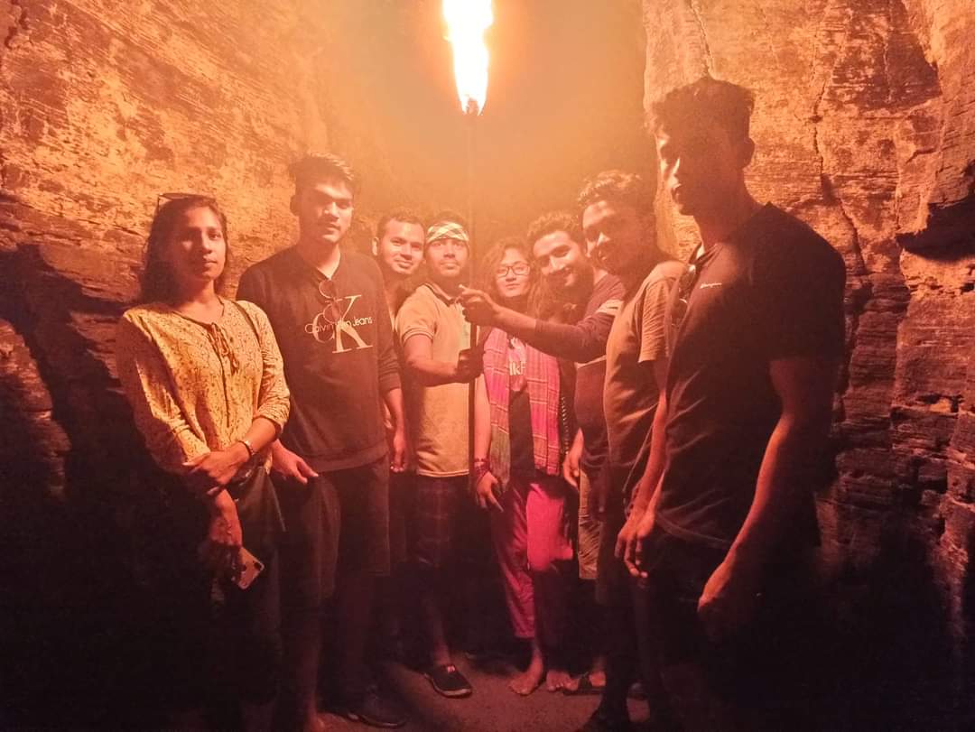
Ailr Cave is situated in Alikadam Upazila of Bandarban in Chittagong, Bangladesh. Now a day in Bangladesh, Ailr Cave is popular hiking place for travelers. This cave located at the top of two hills near Matamuhuri-Tuino canal (Khal). Alir Cave is just three km away from Alikadam Town. Three consecutive caves have been found in this area. No one can say whether these caves are made naturally or artificially. Those caves are made of soil and stone and those are one hundred& fifty feet above jhiri Path. Those elongated caves in the middle of the hill are about 100 feet long. The Caves are very dark inside. So you have to go inside with torch light or moshal (torch).
Ailkadam to Alir Cave:
You have to rent a boat from Alikadam Army zone. The boat will drop you off at the outside of Ali’s tunnel. After getting off the boat and walking some distance through the tunnel, you will find those caves.
Dim (Egg) Hill:
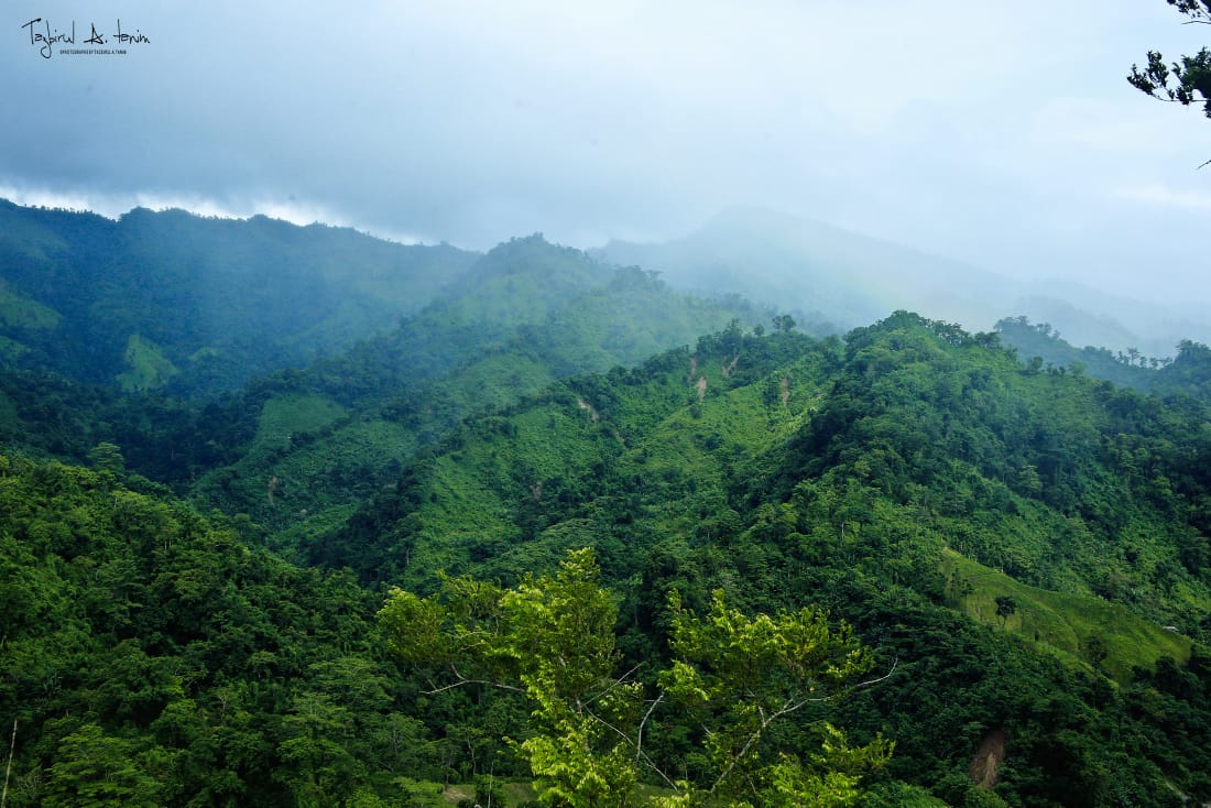
Dim Hill of Thanchi- Alikadam road is the highest road in the Bangladesh. Now a days, Dim Hill very popular hill for the tourist. According to the locals, this hill looks like an egg, so it is called Dim (egg) Hill. This hill is located in the middle of Thanchi and Alikadam Thana. This Hill about three thousand feet above sea level. Dim hill area in the middle of the 33 km long road has attracted more tourists. From this road, all see is green and green. The Sankh River flowing down from this road can be seen is very small. Looking down at the house from the top of the hill, it looks like a small toy houses. This road rises from Alikadam and the height of the road near Dim Hill stands at 2500 feet. Thanchi- Alikadam, 30 km from Alikadam Upazila, is a hilly road.
Alikadam to Dim Hill:
From Bandarban city, go to Thanchi Bazar by local bus or Chander Gari (Jeep). After that, Chander Gari( Jeep)/motorbike from Thanchi Bazar to Dim Hill.
Marayon Tung:
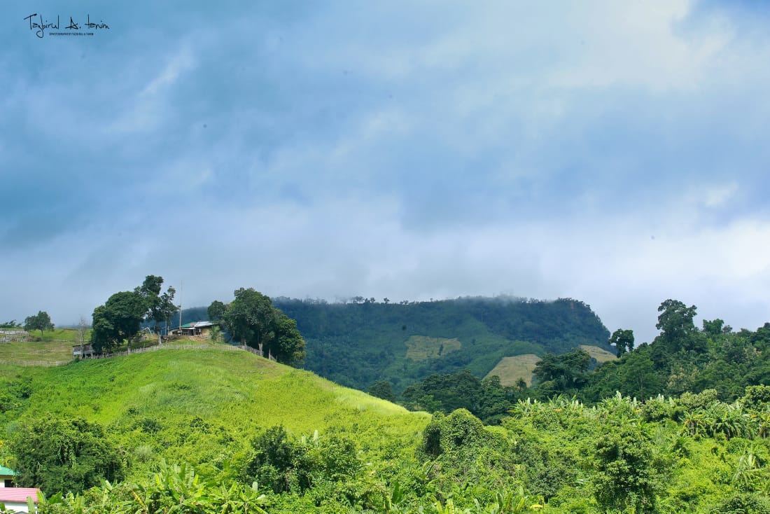
Marayon Tung is also known as Marayon Dong. It is located in Alikadam Upazila ( Mirinja range), at Bandarban. The height of this mountain is about 1840 feet. This place is also excellent as a spot of interest. As far as the view from here is just green hills and hills. The river Matamuhuri is flowing like a snake below. The Marayon Tong mountain is home to various indigenous peoples. They built their houses( tanghar) on the slopes of the mountain. The top of the Marayon Tung has a huge statue of Buddha and is a very sacred place for Buddhists Shrine. This Jadi is surrounded an open, upper canopy & inside is a huge statue of Buddha. In fact, the top of this mountain is a very popular place for tourists to camp and this is a good place for camping. Usually tourists come here for camp. Tourists are getting shopping from Ali Kadam Residential Bazar to Bar-B-Q at night on Marayon Tung top.
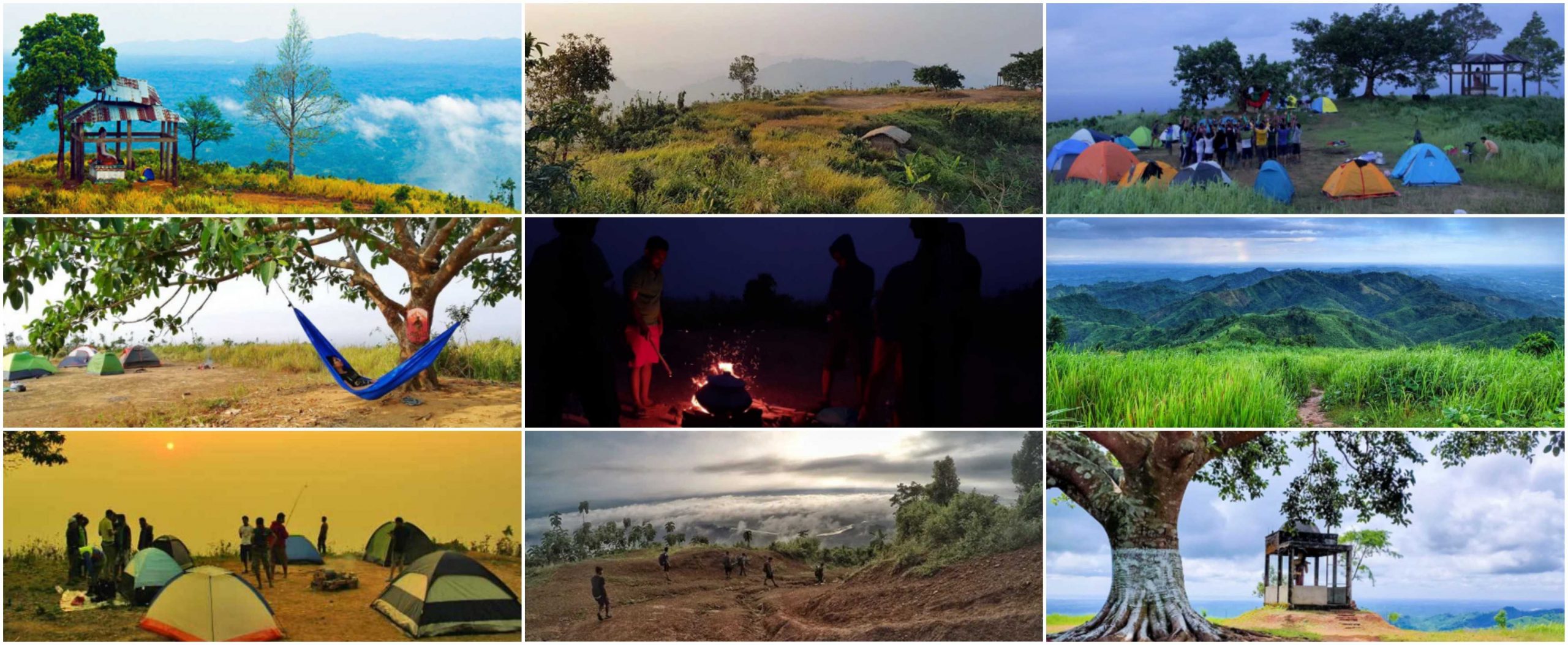
Alikadam to Marayon Tung:
There is a direct bus from Dhaka to Ali Kadam bus stand. From Alikadam you will go to the Alikadam Residential by auto. Then take the road on the right and again yon can go from Alikadam Residential to below Marayon Tung by auto. After reaching there, you can walk for half and three/ four hours to reach the top of the mountain.
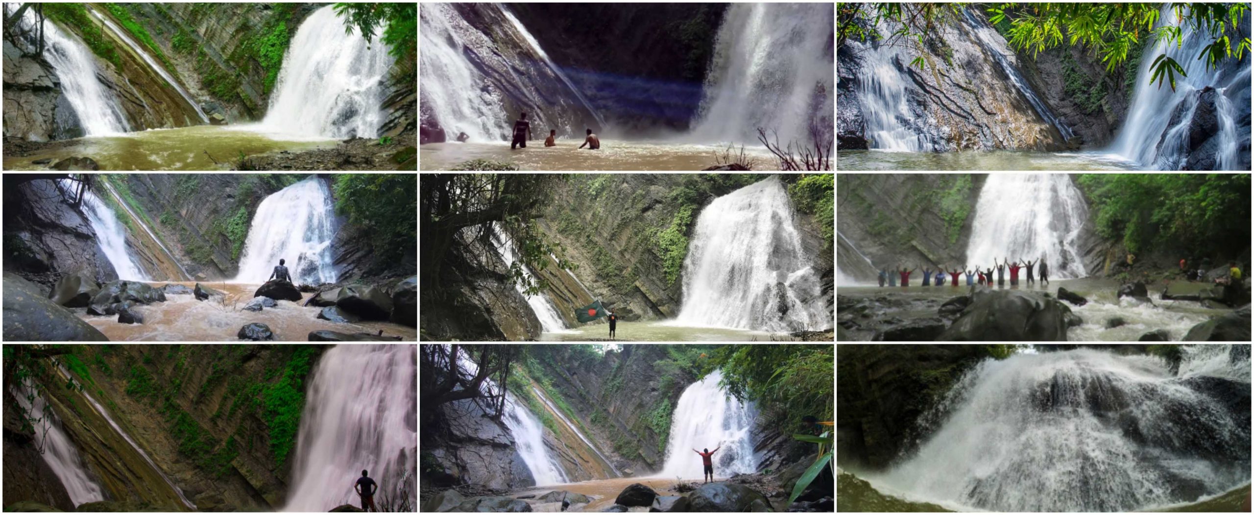
Dumtua/Tuk O/Lamonai Waterfall:
Dumtua Waterfall is located in Alikadam at Bandarban. This Waterfall has many name. It is better to know about naming this Waterfall first. Dumtua means “steep shaped walls”. For its steep shape, frogs/fish cannot climb over its wall. So the locals call it “Dumtua”. The water source on the right side of this Waterfall is called “Bang(frog) Jhiri”. In Murang language, “Tuk” means ‘frog’ & “O” means ‘Jhiri’. Since this Waterfall is located in Murang area, the name of this Waterfall is “Tuk O” in the local language. The locals also call it “Lamoni Waterfall” as the two faced waterfall creates a different beauty in the moonlight. In Murang language “Lamo” means ‘moon’ & “Nai” means ‘light’. Dumtua Waterfall can be visited at any time of the year. Since it is very beautiful to see Waterfall/Fountain (Jhorna) in the rainy season or after the rainy season, it is better to go at that time. However, when it rains a lot, the way to go becomes very difficult.
*Note:
- Must take a Guide. There is a guide association in Adupara. The guide will cost TK.1000 (it is fixed).
- Must take with you Voter ID Card/ photocopy of college or university ID card/ birth certificate/ passport.
- Must take trekking shoes.
- Important point, you have to report to the army camp (after reaching 10 km on the way from Alikadam). You must enter there with your national ID card and phone number and get permission to go ahead. And remember that you must finish you tour on the same day. And return to this 10 kg army camp before 5 pm and report (time should be taken care of).
- Be sure to bring dry food, saline, water and some first aid with you.
- To keep the weight of your backpack as low as possible.
Alikadam to Dumtua Waterfall:
First you have to come to Alikadam Pan Bazar. From there you have to come to Adupara by 17 km by Motorbike/Chander Gari (Jeep). You have to take a guide from Adupara. You can reach Damtua Waterfall by crossing the remote hills for 3 hours from Adupara.
Wang-pa Waterfall:
Wang-pa Waterfall is the craziest Waterfall in the Bangladesh. Wang-Pa is a waterfall, which is hidden itself. After returning from Damtua waterfall, you can visit Wang-Pa Waterfall. This Waterfall is located in the deepest forest in Alikadam at Bandarban and this waterfall still hidden from public view. Many people just come to see Damtua Waterfall but this Wang-pa Waterfall is near Dumtua Waterfall. The trekking route is difficult. And the beauty of Wang-Pa waterfall is different from other waterfalls. The rainy season is the best season to visit this Waterfall. But when it rains a lot, the way to this Waterfall becomes very inaccessible. Wang-pa is falling with great speed through the big steep wall. If you have a rope with you can go easily. You have to climb the steep wall about 60 degrees and go in front of the Waterfall. The sound of the water falling has been heard all around.
*Note:
- If you take the purpose of visiting Dumtua Waterfall, you will be able to see it at the same time. In that case the guide doses not have to pay extra money. But you must talk to him about Wang-pa Waterfall.
- If you go in the rain, you will find leeches on the trail. So you can keep salt with you.
- Keep a large rope with you, and then it will not be difficult to go the Waterfall.
- Keep dry food and water with you during the trek.
Alikadam to Wang-pa Waterfall:
When you come back after seeing Dumtua Waterfall, you guys will get a Para named Member Para. Leaving this Para, a narrow road on the right hand side descends to the bottom of the hill and as soon as you take this road, you will see the Wang-pa Waterfall.
Tainum O Jhorna:
Tainum Jhorna is located in Tainum Jhiri, Kurukpata Union, Alikadam ar Bandarban. In Mro languare, “Tainum O” , “Tai” means ‘water’ “num” means ‘black’ and “O” means ‘Jhiri’. That’s stand for “Tainum O” means “Black Water Jhiri”
Alikadam to Tainum O Jhorna:
From Alikadam bus stand, you have to take an auto to the Matamuhuri river Motorboat (Trawler) ghat next to Alikadam Cantonment. From the ghat the local motorboat goes to Poyamuhuri Bazar (you will get motorboat {trawler} to Poyamuhuri on Saturday and Tuesday). The time will take about 4 hour. If you go a little further from Poyamuhuri Bazar to Matamuhuri, you will see Tuinum Jhiri on the left hand side. If you walk 15/20 minutes along the Jhiri, you will see the Tainum Jhorna.
*note:
- The biggest thing is to get permission from Alikadam Cantonment. There is no guarantee that you will get permission all the day.
- It is better to take the reserve motorboat (trawler) because the local goes to Poyamuhuri market.
- The reserve will take around TK.5000-6000. When the water level in the river decreases, the rent increases.
- You can also see two Jhornas before Poyamuhuri Bazar and another one below Poyamuhuri Camp.
More Tourist place in Alikadam:
- Rupmuhuri Jhorna
- Palang Khyang Jhorna
- Matamuhuri River
- Poyamuhuri Jhorna
- Tinam Jhorna etc.
Where do you stay?
There is no better way to stay in Alikadam. The District council has a post bungalow located a short distance from the bus stand. There are three hotels in Alikadam Bazar. They are- Alikadam Guest House, Hotel Damtua, Hotel Alikadam. There is also some boarding system in Alikadam Bazar. The rent is between TK.800-1800. Be sure to talk about rent before taking the room.
Where to eat?
There are some hotels to eat at Alikadam town, Alikadam Residential, Alikadam Panbazar. There are local fodd arrangements, you can eat at low price.
*Note:
- Alikadam, Bandarban is a beautiful and remote area. So, you must keep with your voter ID card/ college or university ID card/ passport.
- You must take permission from the Army camp before going to any spot.
- You must take dry food, water, saline etc. with you before going to those spots.
- It is better not to take children and adults of Alikadam track.
- Be careful when walking on the hilly Jhiris (paths).
- It is not safe to go on a tour along in the spots of Alikadam. Of course, it is best to give Alikadam tour in the group.
- While visiting the spots above Alikadam, you can see the various fields of the residents. Refrain from destroying and stealing the crops of those fields.
- Do good behave with the local people.
- It is our responsibility to keep our tourist spots clean. Let’s keep the spots neat & clean as we go around.
Happy Travelling!! 🙂
Many thanks Afsana Meme for a wonderful review of Alikadam. I am a lone 47 years old traveler. Wonder if anyone would accompany me if I visit there 17-19 Sept 2020. Appreciate your reply.